
Many turf management decisions are inherently spatial—where water is needed, where pests typically occur, and where additional management is required to achieve specific performance goals. Historically, these patterns have been managed through careful observation, note-taking, and sketches on scorecards or aerial photos on the shop wall. GreenKeeper CIS was developed to support spatial decision making through the combination of interactive maps, staff observations, and autonomous sensor data.
The GreenKeeper team is pleased to release the newest version of GreenKeeper CIS ahead of the 2026 GCSAA Conference and Trade Show. This upgrade improves the user experience and interface, increases CIS performance, and expands flexibility for mobile use.
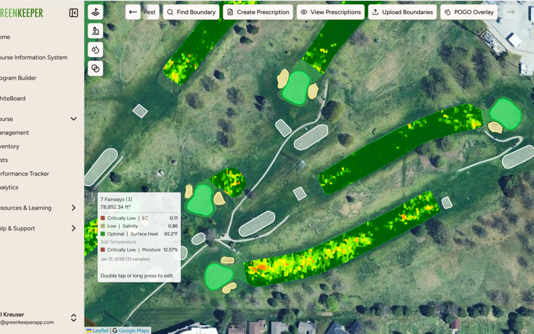
View POGO Data in CIS
POGO soil sensor data are now fully integrated with GreenKeeper CIS. POGO provides rapid, mobile measurements of soil moisture, salinity, and temperature, allowing managers to collect dense datasets across greens, fairways, and other managed areas in a short period of time. This type of mobile sampling helps capture spatial variability that is difficult to assess with fixed sensors alone.
After entering a POGO API key, users can associate POGO boundaries with specific course boundaries within GreenKeeper CIS. Average soil moisture, salinity, surface temperature, and soil temperature values can then be viewed by hovering over individual course features. Boundary colors can also be dynamically displayed to reflect soil moisture, salinity, or temperature values.

Overlay POGO and Turf Vision System Data
CIS also serves as a framework for viewing and interpreting data from GreenKeeper’s Turf Vision system. Turf Vision is a mower-mounted active sensor system that measures light reflectance to assess turfgrass density, nitrogen status, and stress. Viewing Turf Vision outputs alongside POGO data within CIS provides additional context, helping distinguish surface symptoms from underlying soil conditions and supporting more confident management decisions.

Using Boundaries to Turn Spatial Data into Action
Spatial data in CIS are organized using adjustable boundaries that can be refined to reflect how a facility is actually managed. Greens are automatically cropped from collars and approaches, individual course boundaries can be grouped, and larger boundaries can be split into smaller management zones. Users can also add custom boundaries to map pests and identify areas of stress, then use those layers to create prescription maps for targeted or variable-rate applications.
While CIS produces files compatible with GPS-enabled sprayers, GPS equipment is not required to gain value from CIS. Many users rely on CIS maps to guide hand applications, adjust irrigation programs, document pest locations, and create interactive maps that help direct labor across golf courses or athletic field complexes.

Visit GreenKeeper at the 2026 GCSAA Conference
These updates reflect continued development of GreenKeeper CIS as a practical spatial decision-support tool. Improvements to usability and performance, combined with expanded support for sensor-driven and imagery-based workflows, make it easier to capture variability, visualize patterns, and apply spatial information to daily turf management decisions.
We invite attendees of the 2026 GCSAA Conference and Trade Show to visit the GreenKeeper team at the Simplot Turf & Horticulture booth, where CIS and connected sensor integrations will be available through interactive displays. For those unable to attend—or interested in exploring CIS sooner—email the GreenKeeper team to request a trial of GreenKeeper and CIS.
