
Geospatial data is becoming increasingly important to turf managers. These data link observations and measurements to specific locations (latitude/longitude). Examples include locating the position of pests and problem areas, mapping irrigation head and value locations, defining golf course and other turf boundaries for GPS sprayers, and locating issues autonomously with sensors on mowers and drones. All of these data have unique file types (extensions) that can be foreign to most turf managers. You’re probably familiar with PDF, JPG, DOC and XLS file extensions. But, do you how KML, GeoTIFF, and confusing Shapefile clusters are used to manage geospatial data at your course or field?

Boundary Files
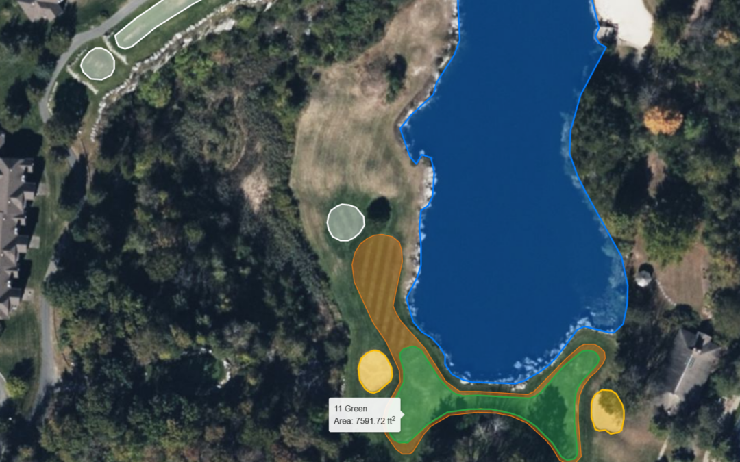
As their name implies, these types of file define different boundaries. They can be fairway mower lines, the green/collar interface, features like tees, bunkers & ponds, or the infield skin of a baseball field. They can also be used map pest locations. Boundary files are typically a series of vertex points/nodes that are linked together by a line. GPS sprayers these files to precisely control nozzles operation which can significantly reduce application over-spray. For example, the Ninja VRT sprayer from Frost Services has reduced spray volume by 20% when we treat the acre of greens at Ager Golf Course compared to a traditional sprayer. Course boundaries can be further divided into smaller regions to create variable rate prescription maps. The same Frost sprayer paired with a Holland Scientific crop sensor reduced nitrogen inputs by 80% compared to our “normal” bentgrass fairway program.
Shapefile Clusters
There are different types of boundary files. The industry standard are called shapefiles. A confusing aspect to shapefiles is that several different files with different extensions are needed to open a job. Imagine trying to open a Word document on your computer but having to load three or four files instead of one file. This is the case with shapefiles, and it’s the reason they are commonly called shapefile clusters. All the files have the same name (i.e. Greens) but they will have different extensions at the end of the name. It’s mandatory to have at least three files extensions (.shp, .shx, .dbf) to accurately use a shapefile. GreenKeeper CIS will also produce these plus a fourth file (.prj) to accurately project a flat map on the round Earth when making a prescription map.
These different shape files are commonly compressed (or zipped) into one folder. This mininizes the chances of the different files being sepeated. GreenKeeper CIS actually produces a zipped shapefile cluster when a new prescription map is created. Some GPS system, like the John Deere system, will load the entire zipped folder. Others, like the Ninja system from Frost will need to be unzipped into the four files before the can be loaded on the sprayer. Depending on the controller, a USB drive or even a cell-phone connection can be used to move these files on and off the controller. Different manufacturer can help get GreenKeeper CIS prescription maps on any type of GPS-enabled turf sprayer.
Other Boundary Files
There are many other types of boundary files out. Some are proprietary to different sprayer manufacturers (i.e., TopCon, Deere & Ag Leader) while others are more accessible. A noted example is the KML file that was developed for Google Earth. A KMZ file is just a compressed version of a KML file. Unlike shapefiles, most of these formats only need one file compared to three or more, but they can be difficult to manipulate without proprietary software.
GreenKeeper CIS can import KML boundary files to quickly create course boundaries within the program. If your GPS sprayer can only export shapefile or proprietary file type, there on different online programs that can convert shapefile boundaries into KML boundaries. These KML and KMZ files can also be used to show where a sprayer treated, the time, and the application rate. These files are also able to be stored and link to application records in GreenKeeper App. Email our help account if you need to convert many files to save yourself time.
Geospatial data
CSV Data Files
Comma-delineated files – CSVs – are a simple list of data that are separated by commas where a new entry is on a different line. They are typically used as a form of point data with latitude, longitude, date/time, and measurements. An example would be data downloaded from a hand-held moisture meter. The files include attributes like soil moisture, salinity and temperature at a specific location and measurement time.

It’s relatively easy to understand and interpret a few data points in a CSV file, but it is impossible to interpret thousands of measurements. New automated sensor technologies can collect tens of thousands of measurements per acre with this file type. We use Holland Scientific crop sensors to automatically measure turf health (density, chlorophyll, leaf moisture) by simply driving over the turf with our mowers. The screenshot above is only a fraction of data generated from a HS ACS-435 crop sensor attached to a fairway mower. During four hours of mowing, this system logged 30,000+ measurements of turf health in one CSV file.
GreenKeeper App’s new Course Information System can help display all of these data as an interactive image instead of millions of rows raw data. The image below is a picture of all the data contained in the above CSV file. A process called interpolation and averaging within management zones (i.e. irrigation heads locations) are used to make these images are called GeoTIFFs.

GeoTIFF Images
There are plenty of different ways to store images on our phones. Common files include JPG, SVG, RAW and TIFF. JPG files are most common because they are good quality and relatively small compared to other file types. TIFF files are large files because each pixel has specific information associated with it (i.e., exact pixel color). That means 12-megapixel TIFF image would contain 12,000,000 pixels with specific color descriptions. This leads to large files. GeoTIFF files also associate latitude/longitude location, size, and different measurement values. These values can include turf color, canopy temperature, or measurements from a crop sensor. These images can quickly turn into huge files when describing hundreds of acres of land.

Image-based systems on drones capture data as a series of GeoTIFFs. Each pixel represents a small area on the surface of the earth. The supercomputers “stitch” the hundreds or thousands of GeoTIFF images into one GeoTIFF. It is somewhat like taking a panoramic photo on your phone, but over a huge area. These files are data-heavy and exceptionally large (gigabytes). They are so large that software has to break them into small pieces (tiles) to display them on a phone or tablet screen.
To save space, computers can use boundary files to crop the images. For example, measurements outside of the fairways may not be important and can be removed. Sub-boundaries can also be set up to average values within a specific area. The image below shows how sensor data was cropped to fairway boundaries and then sub-divide into zones around irrigation heads or 20×20 foot fertilizer zones. The end result is a colorized image the turf manager can use to adjust irrigation run times or create a custom fertilizer prescription map. GreenKeeper CIS is working to automate all of this processing. A superintendent has enough work, and creating custom GeoTIFFs for hours isn’t a priority for most.

")
the take home point
So, what’s the take home point of this post? It is NOT that geospatial data is too complicated and time consuming to be useful. The point is there are helpful technologies that can improve the efficiency of management. That includes the time of the turfgrass manager. It is important, however, to know what some basic file types to make sense of geospatial data. Software like GreenKeeper CIS are here to streamline these processes and help superintendents and field managers make good decisions about the turf under their care.
Here are the CliffsNotes to help navigate this new technology:
- Geospatial data are measurements associated with a time and location.
- Boundary files describe the different boundaries at your field or golf course
- GPS sprayers used these files to control nozzles
- Shapefiles are common boundary files and they are found in clusters with the same name but different extension at the end of the file name
- At least three are needed to open a shapefile (.shp, .shx, .dbf)
- They are typically Zipped together for easy use and storage
- KML and other file types exist, but are not a universal and harder to modify
- CSV lists of data are difficult to use
- Software creates large GeoTIFF images to help visualize data and amend management data